Links to Page
Please give me comments about this document on this thread at the Groundspeak Forums.
I have been geocaching since July 2005, and I thought I would write a summary of the tools and process I use with the hope that it would be useful to other geocachers and those who are considering becoming geocachers.
As I did my initial research on geocaching, I found a great deal of info on the web, but it was quite fragmented. I couldn't find a description of different geocachers' whole setups, and it was hard to understand how all the pieces would work together without a lot of purchases and trial-and-error. The whole thing is quite complicated for me, and I'm relatively technical, so I thought a holistic explanation would be useful for others, especially beginners.
I should note that the tools and processes I describe below are just one way to go about geocaching. Take the bits and pieces of this document that are appropriate for you.
I should also note upfront that I am assuming you are already familiar with the basic idea of Geocaching. If not, read and explore on Geocaching.com.

I'll start with my GPSr as it is usually the most expensive of the tools you'll need to geocache, and it would be quite a challenge to geocache without one. (Whereas you could probably make do without the other tools I talk about in this document.)
I chose the Garmin GPS 60 after doing just a little bit of research online. From what I read, I gathered that the GPS 60 series from Garmin was quite a common choice for geocachers, but I didn't know why. The main difference I could glean online about the models in the 60 series seemed to be the color screen and the mapping capability and memory for mapping. I figured I really wouldn't need the map (and from what I read, it sounded like the basemaps included in these models were mediocre at best and upgrading to a more comprehensive map would be another $100 or so, so I chose the cheapest one from that series (the GPS 60) to give it a try. (It was about $170 with tax/shipping from Amazon.)
In my mind, the absolutely key features of the GPS 60 series that are important for geocaching are:
Now that I know what I know, there are two main things that I kind of wish I had in my GPSr. Those are:
If you're interested, it looks like the primary differences between the 60CS and the 76CS are the form factor, more map memory and better basemap in the 76CS. Hard to tell, but it sounds like you don't get a basemap in the 60CS capable of doing turn-by-turn directions while you do in the 76CS. Anyway, if I ever decide I'm into geocaching enough to warrant further investment, I'll probably get a 76CS.
Okay, here's where it starts getting interesting. If you're like me, you want to get a whole bunch of waypoints into your GPSr so that you can do several caches in one go. In fact, I try to set it up so that I can do some spurious caching as a side activity to whatever my primary task may be. In order to do this, you have to setup your geocaching system and upload a *lot* of waypoints.
I used to use GPSBabel to convert the .loc file from Geocaching.com to .mps for upload through MapSource (the software that comes with the Garmin GPSr), but I figured out that the update for MapSource now supports .gpx which is the filetype that Geocaching.com PocketQueries supports (see more below.)
Here's how I upload waypoints to my GPSr:
When I started geocaching, I realized it would be a big pain to always plan out exactly which geocaches I would go after and printout (or read ahead of time) all the description pages for the various caches I might try to find in that outing. What would be really cool is if I could always have in my possession the locations and description of all the caches of the general area I am in so whenever I am in the mood and have the time for geocaching, I can do it without a lot of prep work.
In order to achieve this, Pocket Queries, a premium service of Geocaching.com, is key. It allows:
I happen to use a Treo 600 as my cellphone (which is Palm OS based) so I can always have the cache descriptions with me. Conveniently enough, the Pocket Queries function includes a feature to also enclose a .prc eBook file for the Palm with all the cache descriptions in its result email. On the Palm, this eBook file can be read by Mobipocket Reader, and that's what I use.
So here are the specific steps I take when I want to set up a new area for ad-hoc geocaching:
This topic is slightly more advanced, but quite important, I'm realizing. As my wife and I travel a bit more and try to do geocaching on our way, it is becoming clear that managing waypoints (ie. which we've found, which we haven't, which are near where we are going, which are near home, etc.) and keeping the right ones in the GPSr memory is a big hassle. With the help from some folks at the Groundspeak Forums, I've found GSAK (the Geocaching Swiss Army Knife).
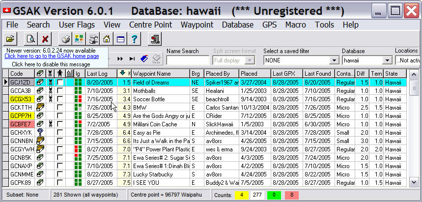
GSAK is neat because it gives a nice display of cache info, and it also allows flexible management of cache databases. For example, I can build a database of caches in Hawaii and load that up when we go there. Then I can load our home db when we get back. You can also use Export -> html files function to create a directory of html files that represent all the cache notes for a given database. These html files can be loaded and viewed on your Palm using Plucker, which is an offline html viewer. It is slightly tricky to get this set up (hint, within the channel setting for Plucker Desktop, choose "ignore links to a server that is different from starting page's server" and set "Retrieve linked pages to a depth of N from the starting page" to 4.) The display is nicer, has more context, and is more interlinked than what MobiPocket gives you, if you're willing to go through the extra trouble. Also, the cache notes in the html docs only represent the caches in your GSAK database so you can travel with a more refined set than the ebook that comes from your original PocketQueries.
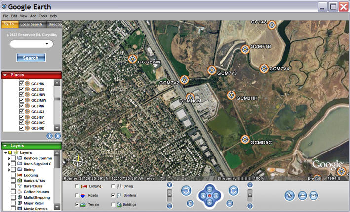

One other tool that I think is really neat to use with geocaching is Google Earth. Google Earth lets you plot all of your waypoints on a satellite map and zoom and pan around to help you locate clusters and help you plan your geocaching outings.
Thanks to the folks at Grounspeak Forums, I have learned that you can actually open .gpx files directly in Google Earth by dragging and droppning your .gpx file onto the Google Earth window, and voila!, there are your waypoints!One interesting set of tools I've found is Jeff Boulter's geocaching tools. (Check the upper left part of the page.) The most useful one for me so far has been the Geocaching Express Logger. I used this on our most prolific geocaching run yet to make it a little easier to log all the finds.
Some folks also swear by CacheMate. CacheMate is a Palm app that basically shows the cache descriptions and lets you log notes per cache. It also let's you find caches in the db near a given location. It supports .gpx and .lco import. I can see how this would be useful if you need to figure out which caches are near you, but that's what I use the GPSr for. I read the cachename off the GPSr and do a search in MobiPocket or Plucker to find the cache note. I'm not sure how much additional value there is in CacheMate, but I might be missing something.
©2005 Fred Delse